
Home-page - Icelandic Meteorological Office
Weather forecast
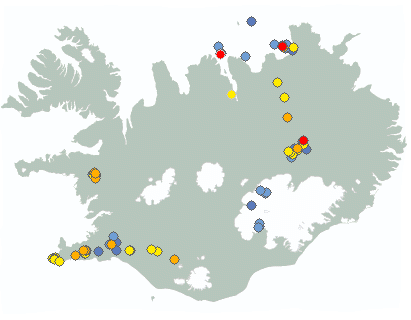
Weather forecast for the next 24 hours
Southerly or variable wind 5-13 m/s and widely rain. Temperature 3 to 9 deg. C. Decreasing precipitation tonight and becoming cooler.
Patchy rain tomorrow. Mostly dry in the northeast parts, but light rain there for a time in the afternoon. Temperature widely 0 to 7 deg. C.
Forecast made 12.01.2025 15:28
If the map and the text forecast differs, then the text forecast applies
Forecast for station - 1
Forecast for station - 2
Forecast for station - 3
Forecast for station - 4
Forecast for station - 5
Maximum wind in Iceland today
| Lowlands | |
|---|---|
| Highlands | |
|---|---|
Maximum and minimum temperature in Iceland today
| Lowlands | |
|---|---|
| Highlands | |
|---|---|
Maximum precipitation in Iceland today
| Lowlands | |
|---|---|
| Highlands | |
|---|---|
Maximum wind in Iceland during the last hour
| Lowlands | |
|---|---|
| Highlands | |
|---|---|
Maximum and minimum temperature in Iceland during the last hour
| Lowlands | |
|---|---|
| Highlands | |
|---|---|
Maximum precipitation in Iceland during the last hour
| Lowlands | |
|---|---|
| Highlands | |
|---|---|
Preliminary results
Earthquakes
Earthquakes during last 48 hours. at 12 Jan 16:05 GMT

Biggest earthquakes during the last 48 hours
| Size | Time | Quality | Location |
|---|---|---|---|
| 2.6 | 12 Jan 09:25:42 | Checked | 14.8 km WSW of Kópasker |
| 2.1 | 11 Jan 03:54:48 | Checked | 13.2 km WNW of Gjögurtá |
| 1.6 | 10 Jan 16:05:39 | Checked | 12.8 km WSW of Kópasker |
| 1.4 | 11 Jan 05:47:04 | Checked | 11.3 km WSW of Kópasker |
| 1.3 | 11 Jan 04:46:58 | Checked | 28.9 km N of Borgarnes |
| 1.2 | 11 Jan 04:13:30 | Checked | 7.5 km ESE of Bárðarbunga |
Week overview -
Earthquake activity throughout the country is described in a weekly summary that is written by a Natural Hazard Specialist. The weekly summary is published on the web every Tuesday. It covers the activity of the previous week in all seismic areas and volcanic systems in the country. If earthquake swarms are ongoing or significant events such as larger earthquakes have occurred during the week, they are specifically discussed. More
Hydrology
Average flow and temperature last 24 hours
| River | Place | Flow | Water temperature |
|---|
Remarks of a specialist
Ice dams are present in many rivers and can cause flooding tomorrow, sunday, due to thawing and rain. Water levels have decrease in the past few days in Hvítá river by the farm Brúnastaðir where an ice dam has formed. The water levels are still high and have been steady for the past day. Travellers are asked to show caution around the river. Predicting how this events develops is difficult, but the IMO continues to monitor the area closely with the help of the Civil protection and the local police.
Due to technical problems we have turned off the service publishing hydrological data on the map. See data here: Real-time monitoring system.
Written by a specialist at 11 Jan 08:24 GMT
Avalanches
Avalanche bulletins for selected areas
The avalanche bulletin is at a regional scale. It does not necessarily represent avalanche danger in urban areas.
| Region | Sun Jan 12 | Mon Jan 13 | Tue Jan 14 |
|---|---|---|---|
|
Southwest corner
|
|
|
|
|
Northern Westfjords
|
|
|
|
|
Tröllaskagi
|
|
|
|
|
Eyjafjörður (experimental)
|
|
|
|
|
Eastfjords
|
|
|
|
News

Magmatic intrusion at considerable depth beneath Grjótárvatn likely
Updated 9. January 12:30 UTC
On Thursday, January 2nd, a tremor event was measured between 5:00 PM and 6:00 PM with its origin at Grjótárvatn. The tremor, lasting about 40 minutes, consisted of a series of continuous small earthquakes, most of which were too small to be located properly. Only two earthquakes within the tremor signal were located, they originated at a depth of approximately 15 km, with magnitudes of M1.5 and 1.8. A total of about 20 earthquakes were recorded that day, all at depths of 15–20 km and magnitudes ranging from M0.1–2.0.
Read more
Magma Accumulation Beneath Svartsengi Continues
Deformation data up to December 30, 2024, indicates that magma accumulation beneath Svartsengi continues. The likelihood of a new magma intrusion and potentially an eruption is expected to increase when the volume of magma beneath Svartsengi matches the amount that left the magma region during the magma intrusion and eruption on November 20. Geodetic model results estimate this volume to be between 12 and 15 million cubic meters. Therefore, the likelihood of magma intrusion and potentially an eruption along the Sundhnúkur crater row may increase as of late January.
Read more
Ground uplift under Svartsengi area continues at a stable rate
A photogrammetric survey was conducted by Icelandic Institute of Natural History and Landmælingar Íslands in a flight over the eruption site 13 December. The data reveals that the lava field that was formed during the last eruption (20 November to 9 December) had a total volume of 49,3 million cubic meters erupted and covered an area of 9,0 square kilometers. The thickest part of the lava field was around the craters and close to the barriers by the Blue Lagoon but the average thickness of the lava was 5,5 meters.
Read more
Ground Uplift and Magma Accumulation Continue Beneath Svartsengi
Updated 19. November at 14:45 UTC
Seismic activity in the Sundhnúkar crater row remains relatively low. A few earthquakes have been recorded daily, most of them located between Stóra-Skógfell and Sýlingarfell. On some days in the past week, bad weather has affected the sensitivity of the seismic monitoring system, potentially obstructing the detection of the smallest earthquakes.
Read more
Continued greenhouse gas emissions could trigger a regional cooling around the North Atlantic
Continued greenhouse gas emissions increase global warming, but could trigger a regional cooling around the North Atlantic. In an open letter released today at the Arctic Circle conference in Reykjavík, Iceland, 44 leading experts on ocean circulation and tipping points from 15 countries appeal to the Nordic Council of Ministers to take this risk seriously, initiate a risk assessment and take steps to minimize this risk as much as possible.
Read more
New Icelandic Met Office weather and climate supercomputer, becomes operational
The National Meteorological Institutes of Iceland, Denmark, Ireland and the Netherlands have joined forces to respond to climate change with more timely weather forecasting on a new, now operational, common supercomputer. This helps prepare each nation for the impacts of weather patterns, which are expected to become more extreme and more challenging to forecast.
Read moreShort articles

Flood warning system and jökulhlaups - Eyjafjallajökull
Jökulhlaups (glacier outburst floods) are more common in Iceland than elsewhere in the world because of the interaction of volcanoes with glaciers. The greatest jökulhlaups from the subglacial Katla volcano are among the largest floods that humans have witnessed.
Read moreNew publications and research
- Michelle Parks, Freysteinn Sigmundsson, Vincent Drouin, Ásta R. Hjartardóttir, Halldór Geirsson, Andrew Hooper, Kristín S. Vogfjörð, Benedikt G. Ófeigsson, Sigrún Hreinsdóttir, Esther H. Jensen, Páll Einarsson, Sara Barsotti & Hildur M. Friðriksdóttir. (2023).
- Sahar Rahpeyma, Benedikt Halldórsson, Birgir Hrafnkelsson & Atefe Darzi. (2023). Frequency-dependent site amplification functions for key geological units in Iceland from a Bayesian hierarchical model for earthquake strong-motions.
- Sara Klaasen, Solvi Thrastarson, Yesim Cubuk-Sabuncu, Kristín Jónsdóttir, Lars Gebraad, Patrick Paitz & Andreas Fichtner. Subclacial volvano monitoring with fiber-optic sensing: Grímsvötn, Iceland. (2023).
- Ismael Vera Rodriquez, Marius P. Isken, Torsten Dahm, Oliver D. Lamb, Sin-Mei Wu, Sigríður Kristjánsdóttir, Kristín Jónsdóttir, Pilar Sanchez-Pastor, John Clinton, Christopher Wollin, Alan F. Baird, Andreas Wuestefeld, Beat Booz, Eva P.S.Eibl, Sebastian Heimann, Bettina P. Goertz-Allmann, Philippe Jousset, Volker Qye, Vala Hjörleifsdóttir, Anne Obermann. (2002).
- Lamb, O.D., Gestrich, J.E., Barnie, T.D., Jónsdóttir, K., Ducrocq, C., Shore, M.J., Lees, J.M., Lee, S.J (2022). Acoustic observations of lava fountain activity during the 2021 Fagradalsfjall eruption, Iceland. Bull Volcanol 84, 96. doi.org/10.1007/s00445-022-01602-3
- Freysteinn Sigmundsson, Michelle Parks, Andrew Hooper, Halldór Geirsson, Kristín S. Vogfjörd, Vincent Drouin, Benedikt G. Ófeigsson, Sigrún Hreinsdóttir, Sigurlaug Hjaltadóttir, Kristín Jónsdóttir, Páll Einarsson, Sara Barsotti, Josef Horálek & Thorbjörg Ágústsdóttir (2022). Deformation and seismicity decline before the 2021 Fagradalsfjall eruption. Nature 609, 523–528. doi.org/10.1038/s41586-022-05083-4
Search
Contact IMO
© Veðurstofa Íslands | Bústaðavegi 7- 9 | 105 Reykjavík | Phone 522 6000 | Fax: 522 6001
Recording 902 0600 | SSN 630908-0350
Contact us | Employees | Terms and conditions | Sitemap


