
Users' diaries

Recent diary entries
人気のあるプロジェクトに参加するTesla Challenge: Add parking aisles to lots ⇗
歩数 1. 駐車スペースを見つける周囲それは管理可能なサイズです
2.手描きOK恐れるな 上級者向け角度や形よりもうるさい傾向がある
3.場所タグ preset › Higways › Streets › parking_aisle 私の論理は、境界をタグ付けしないことです 駐車場のポリゴンに接続しないでください(そのような場合は簡単に見つけられます)
あなたならできる!
空のスペースにウェイを追加する

josm plugins Gridify
推奨: ○ Tesla
永遠にマッピングを学ぶ JOSM | josm-tested.jar (version 15625) https://josm.openstreetmap.de/

I’m documenting some seasonal 12 days of mapping on twitter
Alternatively, the thread can be viewed here on Thread Reader App
Another 4 days to go, probably on a new thread.

O Mapathona Bahia Acontece Sábado dia 11 de Janeiro de 2020 - Evento OnLine.
Posted by raphaelmirc on 2 January 2020 in Brazilian Portuguese (Português do Brasil)MAPEIA BAHIA - 11 DE JANEIRO DE 2020. BRAZIL.

O Mapathona Bahia Acontece Online no Sábado dia 11 de Janeiro de 2020 Entre 00:00h e 23:59h(UTC-3), horário de Salvador.
O Mapathona Bahia é um evento Online liderado pela UMAPE-OSM União dos Mapeadores de Pernambuco e que os participantes usam o OpenStreetMap (OSM) para mapear áreas em necessidades, onde os dados ajudarão a contribuir para a ajuda humanitária internacional e Local.
Muitas dessas áreas são vulneráveis a desastres naturais e mudanças climáticas, e o entendimento de sua geografia é importante para a maneira como a ajuda é fornecida. Qualquer lugar do mundo pode ser mapeado, mas a prioridade vai para as Cidades da Bahia.
Este Mapathon se concentrará no Mapeamento de Nomes de Ruas e Avenidas que não tem nome em algumas Cidades da Bahia fazendo com que as Ruas Mapeadas passe a ter seus Nomes.
Os dados do Evento pode ser encontrado no site de Divulgação do Evento no Link. https://guiaosmbr.webnode.com/mapeiabahia/
e também em nossa Wiki. https://wiki.openstreetmap.org/wiki/Pt:Mapatona/Mapeia_Bahia
Link da Tarefa Abaixo para Mapeamento. https://tareas.openstreetmap.co/project/155
Noticia no Twitter; https://twitter.com/Umape6/status/1212678049508077571
UMAPE - União dos Mapeadores de Pernambuco - OpenstreetMap.

Contato atraves do Telegram; https://telegram.me/osm_pernambuco
Raphael_PE
Recife/PE - Brazil.
Sveiki,
Kāds var ieteikt kā labāk pievienot uzņēmumu kartē? Vēlos pievienot datu centru
私の好みのレイアウト
作業モード左サイドバー 窓右サイドバー 設定可能な上部ツールバー
友達のようなレイアウトは何ですか?
永遠にマッピングを学ぶ JOSM | josm-tested.jar (version 15553) https://josm.openstreetmap.de/
Lass uns OSMAND besser machen
korrekte ÖPNV-Routen gefunden Schleifenbildung in OSMAND
festgestellte nichtlineare Strecken könnten die Berechnungen des öffentlichen Verkehrs beeinflussen
Tramline route based on node UTM 53N 545115 3830387:  Tramline route based on node UTM 53N 545076 3830334:
Rrepro:
- ausgewählte Hankai North➟South route ˃ viele Male den ‘Next’ Knopf gedrückt ˃ Straßensperre auf Sumiyoshi stop
- ausgewählte Hankai South➟North route ˃ viele Male den ‘Next’ Knopf gedrückt ˃ überspringt Routenwarteschlange
suspect: Gemeinschaftsentscheidung changeset 24812618 Hankai Tramway: use one map track per real track (allows for precise tramway route relations)
Fehler bei Stationshaltestellen innerhalb relations
Sumiyoshi Tram stops x2 on HN tramline:
Ishizu-kita Tram stops x2 on HN tramline:
Referanz: guideline-pt/blog , geofabrik.de osmi
Lass uns OSMAND besser machen

Mari Petakan Pembayaran Nontunai Indonesia di OpenStreetMap! (Revisi)
Posted by Reinhart Previano on 2 January 2020 in Indonesian (Bahasa Indonesia)Pertama-tama, saya mengucapkan Selamat Tahun Baru yang ke 2020!!!

Dengan maraknya program Gerakan Nasional Non Tunai (GNNT) yang diselenggarakan pemerintah sejak 2014, saya mengajak para penyunting peta (editor/mapper) untuk bersama-sama memetakan metode pembayaran yang diterima di Indonesia, misalnya dalam restoran, kafe, tempat parkir, halte, jalan tol, tetokoan, dan lain-lain.
Untuk Apa Dipetakan?
Dengan memetakan pembayaran nontunai di OpenStreetMap, para pengguna dapat langsung mengetahui pembayaran yang diterima dalam tempat tersebut (setidaknya di dalam situs www.openstreetmap.org). Hal ini akan memudahkan mereka untuk mencari tempat-tempat yang menawarkan penawaran diskon/cashback dengan lebih cepat dibandingkan dengan peta daring (online) lainnya.
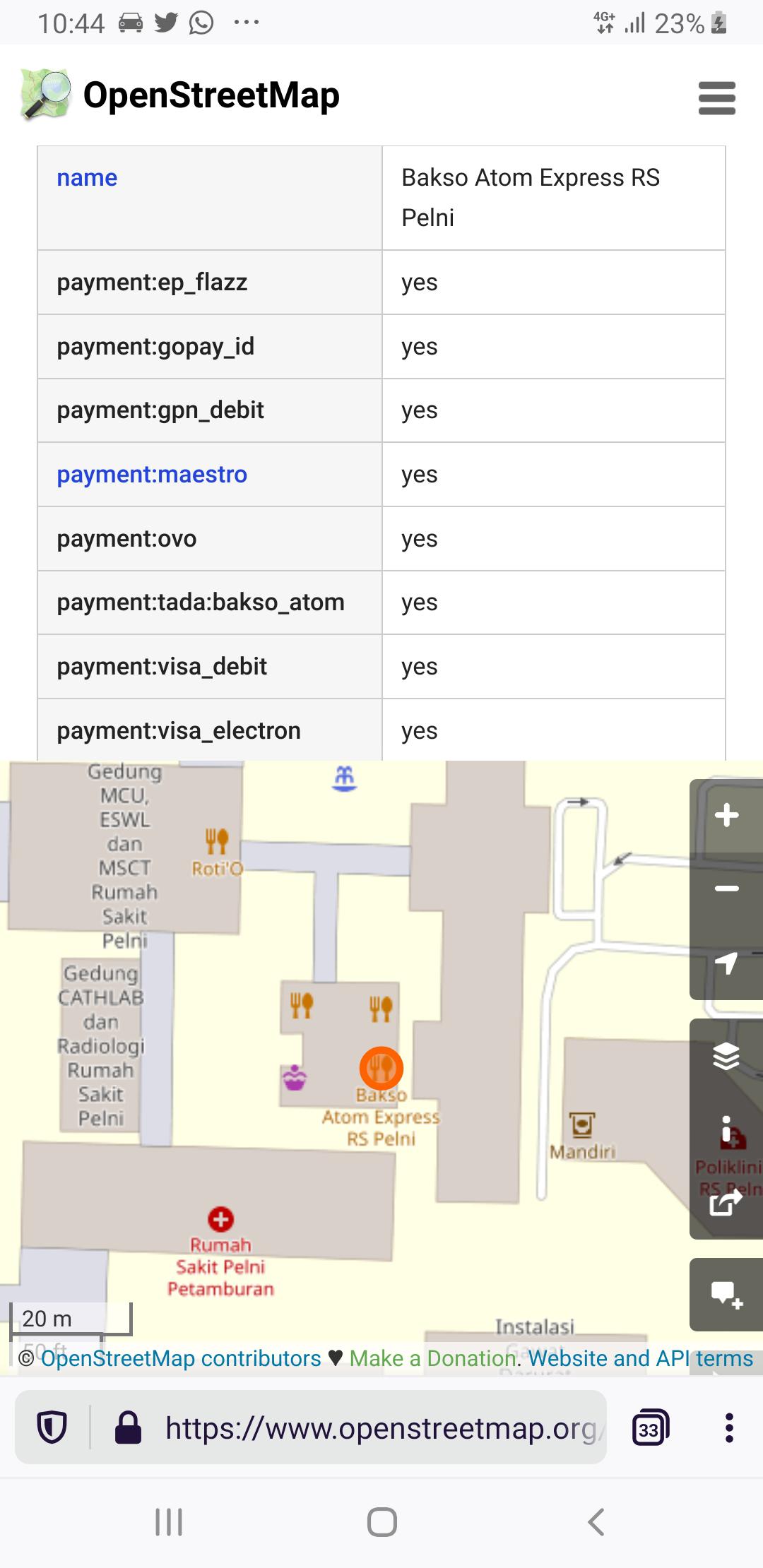 Nah, kalau gini kan saya sudah tahu restoran ini bisa bayar pakai apa…
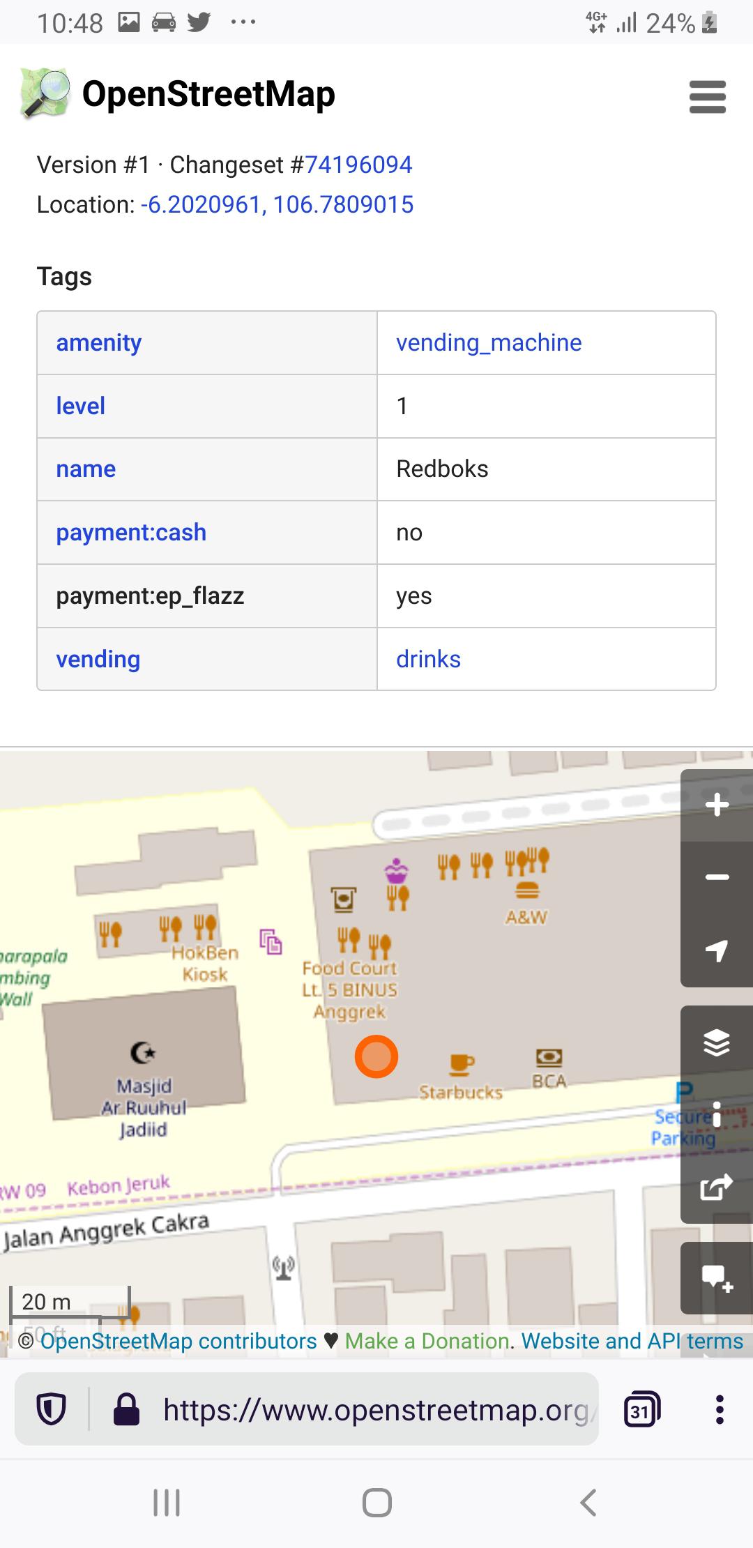 Oh, ternyata mesin vending minuman ini cuman bisa bayar pakai Flazz…
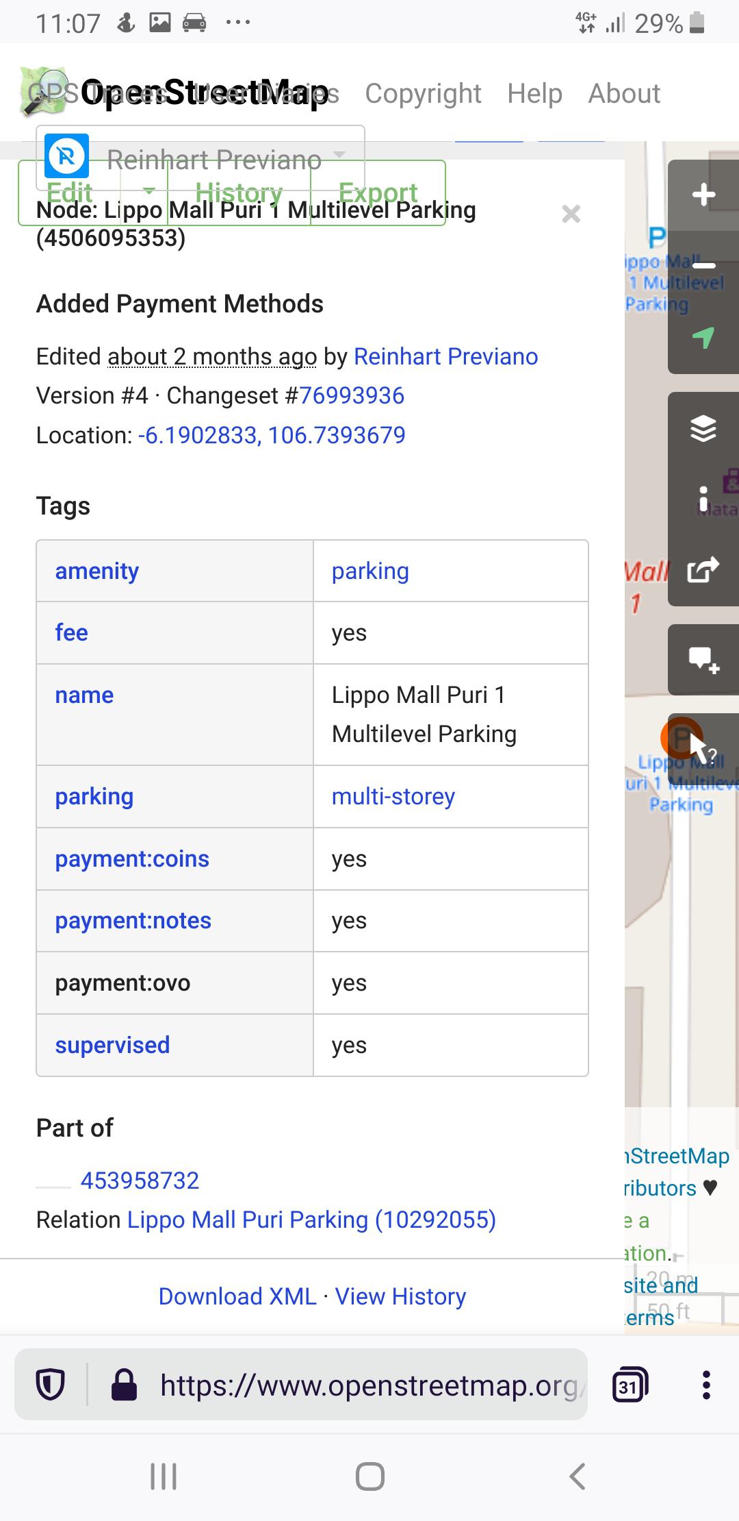 Bayar parkir lewat aplikasi bisa dapat cashback? Di sini ya?
Secara tidak langsung kita juga dapat melihat pergerakan pembayaran digital di Indonesia (misal. dengan melihat frekuensi jumlah merchant pembayaran digital yang ada dalam perkotaan hingga pedesaan), serta memperbaiki kualitas data peta Indonesia dalam OpenStreetMap. Ini semua karena database OpenStreetMap sangat terbuka bagi siapa saja untuk mengunduh dan mengolahnya.
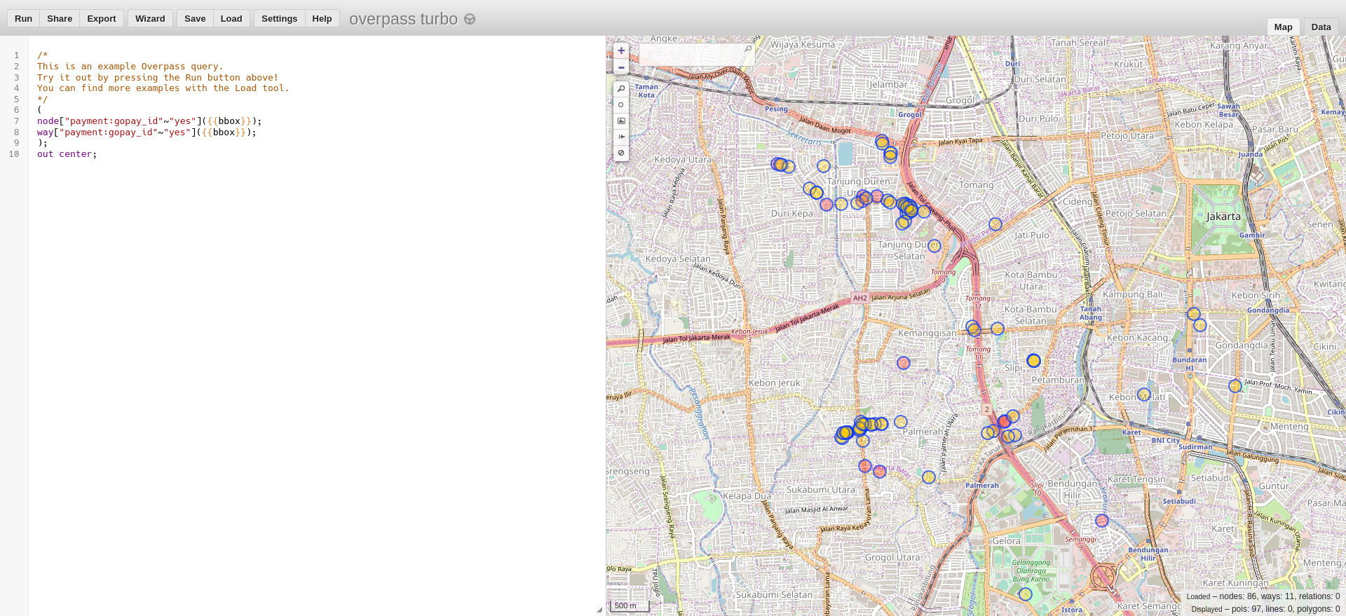 Contoh hasil pencarian Overpass Turbo terhadap tetokoan yang menerima pembayaran menggunakan GoPay
Panduan Tagging (Penandaan)
Kalau bisa bayar pakai uang tunai, tandai dengan payment:cash=yes. Kalau tidak bisa, tandai dengan payment:cash=no.
Kalau bisa bayar pakai kartu uang elektronik, tandai dengan:
payment:ep_flazz=yesuntuk Flazz (BCA, Danamon, dll.)payment:ep_mandiri_emoney=yesuntuk Mandiri e-money (Bank Mandiri)payment:ep_brizzi=yesuntuk BRIZZI (BRI)payment:ep_tapcash=yesuntuk TapCash (BNI)payment:ep_bsbcash=yesuntuk BSB Cash (Bank Sumsel Babel)payment:ep_jak_lingko=yesuntuk kartu Jak Lingko (Transjakarta/MRT Jakarta/Pemprov DKI Jakarta)payment:ep_jakcard=yesuntuk kartu JakCard (Bank DKI)payment:ep_megacash=yesuntuk kartu MEGACASH (Bank MEGA)payment:ep_nobu_emoney=yesuntuk kartu NOBU E-Money (Bank NOBU)
Kalau bisa bayar pakai aplikasi dompet digital (ya, yang ada banyak promo cashback-nya), tandai dengan:
payment:gopay_id=yesuntuk GoPay (untuk membedakan dari [GOPAY (Malaysia)])(https://gopay.com.my)payment:ovo=yesuntuk OVO, dan jugapayment:grabpay=yesuntuk stiker QR Code milik OVO (karena bisa bayar lewat aplikasi Grab)payment:linkaja=yesuntuk LinkAjapayment:dana=yesdanpayment:samsung_pay=yesuntuk DANApayment:yukk=yesuntuk YUKKpayment:shopeepay=yesuntuk ShopeePaypayment:isaku=yesuntuk i.sakupayment:cashbac=yesuntuk Cashbacpayment:bluepay=yesuntuk BLUEPay (diterima di semua vending machine BlueMart)payment:akulaku=yesuntuk Akulaku Paypayment:dimo_pay=yesuntuk Dimo Pay by QR (Untuk aplikasi seperti PayTren)payment:otto_pay=yesuntuk stiker QR Code OttoPay (misal. di Indomaret dan KFC; untuk aplikasi seperti OttoCash dan Bank DKI JakMobile)
Kalau tempat tersebut dapat menerima pembayaran melalui QRIS (QR Code Indonesian Standard) tandai dengan payment:gpn_qris=yes dan payment:<nama bank atau dompet digital yang mengeluarkan kode QRIS>:gpn_qris=yes, misalnya:
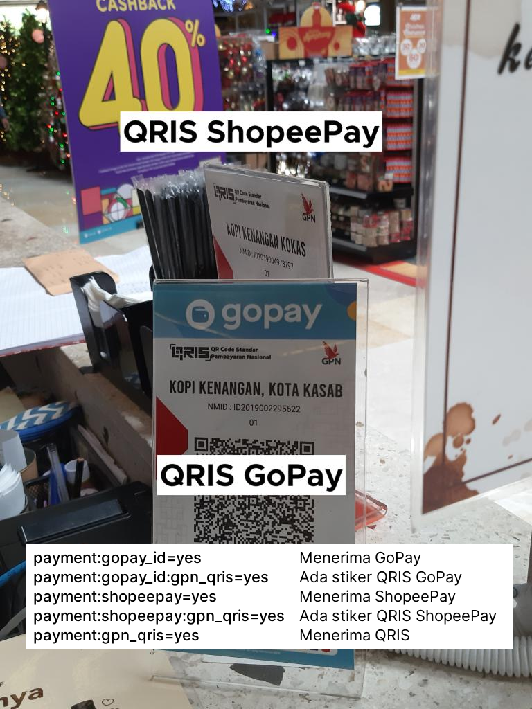
Untuk QR Code GoPay, hanya tandai
payment:gpn_qris=yesdanpayment:gopay_id:gpn_qris=yesjika mempunyai QR Code yang berlogo QRIS.
Khusus untuk kartu debit dan kartu kredit, Anda harus menandai masing-masing tag berikut:
payment:gpn_debit=yesuntuk GPNpayment:bca_card=yesuntuk BCA Card (biasanya diterima di seluruh EDC BCA)payment:mastercard=yesdanpayment:visa=yesuntuk kartu kredit Mastercard dan Visa (umumnya diterima dalam semua EDC bank di Indonesia)payment:maestro=yes,payment:mastercard_debit=yes,payment:visa_debit=yes, danpayment:visa_electron=yesuntuk kartu debit Mastercard dan Visa (umumnya diterima di semua EDC bank di Indonesia)payment:american_express=yesuntuk kartu debit American Express (AMEX)payment:jcb=yesuntuk kartu kredit JCBpayment:unionpayuntuk kartu kredit UnionPay
Ada Pertanyaan?
Jika ada berbagai pertanyaan, silakan bertanya di kolom komentar bawah ini. Saat ini saya juga aktif dalam memetakan restoran di sekitar Slipi, Tanjung Duren, dan Kemanggisan (bisa dibuktikan di situs HDYC). Terima kasih.

#2019 in Retrospect :My Passionate Bits of Contribution to #OpenStreetMap Community #UniqueMappers OpenStreetMapNigeria
Posted by vicksun on 1 January 2020 in English (English)Looking back to 2019,I have the following bits of contributions and moments for my diary record in favour of OpenStreetMap Community and sustainability.
1 . Initiated and hosted series of planing meetings to activate community participation ,growth and expansion of OpenStreetMap Community in Nigeria ,especially,in January 2019.
2 . Contributed and also advocated for HOT Microgrant 2019 donations
3 . Applied for HOT Microgrant 2019 to drive Local community projects in Nigeria but luck was not on our side
4 . Participated in Regional Meetings for OSM Africa Coordination ,especially,when,time permits
5 . In April ,I made sure my local community hosted International Women Day (IWD)2019 to drive gender equality in mapping community and geospatial women empowerment.This also was used to campaign for LetGirlsMap program. For me ,this event has come to stay after succesully hosting it same period in 2018. For 2019 IWD ,the event was tagged :Geospatial Technology the Solution for Women Transformation:Balance for better.
6 . From July to August ,facilitated Mapathon training for Local UniqueMappers Communities at Abia State,Imo State ,Enugu State and Anambra State respectively in Nigeria
7 . Started up UniqueMappers Awka at Nmandi Azikiwe University Awka with the help of Prof.Ifeanyi Enete who mobilzed compus community members comprising of students and staff
8 . Started up UniqueMappers Yola credits to Nnadozie Onyeukwu (State Coordinator) and Saliha who worked very hard to kick-start activities for this local team of UniqueMappers without me travelling to Adamawa state to coordinate.And todate their whatsaap group is quite lively and with active osmites.
9 . Finally succeeded in getting UniqueMappers registered with the Federal Government of Nigeria as the NGO for OpenStreetMap Nigeria Community.This would help to re-position our OSM community efforts for effective project and stake-holders driven community engagement
10 . I missed the State of the Map Conference in Germany and Cote d’ Ivoire -State of the Map Africa ,as well as HOT Summit 2019 in Germany,due to unavailability of travel fund,but ,no worries because,I already had a good deal from FOSS4G2019 Bucharest ,thanks ,to UNFPA for such an amazing support ,giving me opportunity to break the virtual barrier to interact with Prof .Maria Broveli (My OSM Research Mentor) ,Marco and so many others.
11 . And for GODAN giving me the opportunity to meet with Nathalie Sidibe,Enoch Faneva and other OSM Africa Community members for the first time ,tinkering around the use of OSM for agriculture and nutrition at the African Geospatial Data and Internet Conference (AGDIC) 2019 in Ghana .It was all about using OSM and GeoForAll to drive SDG 2
12 . ANd no worries yet,because,I had 2 of my local community leaders:Ezugwu Victor and Mary Marcellineous who also attended the state of the map Africa in Cote d’ Ivoire….Thanks to Geoffery Kateregga for the support
13 . Thanks to Victor Ezeuqwu and Geoffery Keteregga for a good job at the NYSC camp mobilizing and training more than 1000 graguate youths to help us start up a local community at UniqueMappers Kogi .Looking forward to more active participation and coordination via Victor Ezugwu-State Coordinator-UniqueMappers-Kogi
14 . Mobilized to Celebrate UniqueMappers Nigeria 2nd Anniversary and OSM 15 Anniversary…It was also time for the community to have fun
15 . Had meeting with Tyler Radford for Capacity building support ,and other meetings and mails over quality mapping issues in Nigeria OSM.Thanks to Andrew Wiseman and Chad Bevin for your support and follow-ups
16 . Had Mapping Tasks for Disaster Risk Reduction and academic research for Oill Spill community response mapathons.
17 . Had not less than 100 newbies signed up to OSM via community growth and expansion in Nigeria
18 .In december,I lead local community leaders to the field for Community drone Mapping in preparation of our next Mapathon to drive #SDG2
19 . Recorded on closing for 2019 more than 140,000 edits on the UniqueMappersTeam missing maps leaders board http://www.missingmaps.org/leaderboards/#/uniquemappersteam
20 . I also campaigned and coordinated #OSMGeoweek2019 event in various parts of Nigeria in November.And it was also time for us to reach out to the high schools for an inclusive community.
21.Yea,I also applied with Local leaders to host State of the Map Africa 2019,but ,we lost it to Cote d’ Voire .A good experience to prepare best for the next opportunity,at all we are growing bigger and stronger with both private and public sector involvement in OSM Nigeria.
22 . And you know as a lecturer,I was able to smoothly introduce and teach OSM as part of my course content for undergraduate digital Cartography and Open Source Cartography,and to see students dealing with such questions as ‘’ Discuss OpenStreetMap as a Wikipedia of Cartography’’
23 . Had my students research projects data open Source GIS and OSM-driven,increasing UniqueMappers SDG target for quality education.
24 . As a HOT Voting Member ,and community working group member as well as OpenStreetMap Foundation member,I had more time to building the Local Community than participation at the global community.
Will add more ……..later…..but I want to say thank you to every who made it possible for me to impact in one way or the other via OSM Community in Nigeria and beyond !!

What?
There is a place to be mapped. The area is usually too large for one guy. Involving a team of mappers is, therefore, evident. And there is an excellent approach to solving big problems called divide and conquer. Therefore Divide and map. Now. – the damn project.
The goal is to split a large area to squares a human can map. Then, lock a square, work on it, and mark ready for review. Lock again, review the square, and mark as done. The project is here to avoid overwriting work between mappers.
If this sounds familiar, you probably know the HOT’s Tasking Manager. (HOT stands for the Humanitarian OpenStreetMap Team.)
Why?
There are issues with the HOT Tasking Manager. Mainly performance issues. Then, slowly forgetting about essential functionality. Unwanted updates as the necessity of email address (I really hate this!). And only one repository for the whole project.
These are technical issues, however. What about community issues? Why Google disk when there is OpenStreetMap wiki? Why Slack where you must be invited and logged to (just!) see the history? Why all these sign-up Google forms to contribute? I will try to guess an answer – because HOT is a company (even non-profit) and does not know how to be an open community.
Before you ask “If you are so smart, why you do not contribute to Tasking Manager?”, I tried 1, 2, 3, 4. However, there is no real discussion about the future of the Tasking Manager. The future is already decided; openness means that you can see the source code and fix bugs. Nothing more.
Who?
Let’s talk about the potential damn community. It starts with mappers. I will split mappers to novices, experts, reviewers (or validators), and mentors. Mappers are the most critical and the largest group, so the tool they use should be efficient, stable, and comfortable.
Novice mappers perhaps have different needs than experts or reviewers. Mentors, on the other side, probably need to be as close as possible to novices to help them. All of them use the tool differently.
The next are guys with a place to be mapped. Their goal is to point to an area, provide the necessary information, and let mappers do their job – completely different tool usage.
The last (but not least) part of the damn community are developers. They should communicate with the whole community and deliver the tool.
How?
I will try to explain how to create the tool that satisfies Who, do What, and avoids Why. The damn project tends to be proof of concept.
Novice mappers, along with mentors, probably use a web browser. Make a web application then. That could include web chat, maybe? However, remember the primary goal! Let novice mappers map and make mistakes. Let mentors reach the novices as quickly as possible and mark their mistakes efficiently.
Expert users use JOSM. JOSM plugin is the only possible solution here. Maybe other users use a different specialized tool? Make the plugin for that tool, too.
Another web application can help guys publishing places to map. But not necessarily a web app. What about some script? Maybe with some support of so popular machine-learning? Why creating areas to map couldn’t be done by computer? And then just confirmed by some (perhaps another) tool?
You need to serve all these clients with a centralized data store. That’s the backend server.
For each client, create a communication channel between users and developers, namely between novice users, mentors, and mapping web app developers. Then between JOSM users and JOSM plugin developers. Finally, between all the clients’ developers and backend server developers. Everyone involved should also be able to communicate with everyone else.
Always support new clients. One tool just can’t fit all mappers.
Damn project
The damn project is composed of multiple repositories. The central application is damn_server 5 source – backend server written in python using the async FastAPI framework.
There are damn_client (web application, 6 source) and JOSM damn_plugin 7 as main damn clients. There is damn_manager (web application, 8 source) for creating areas to map.
All the repositories are in damn-project group on Gitlab. There is damn-project community chat on Gitter. When needed, new channels on Gitter will be created.
The damn project is proof of concept. It suffers from performance issues because the damn server runs on basic DigitalOcean droplet with 1GB RAM, 1vCPU, 1TB transfer, 25GB SSD disk. There are, of course, more issues.

My State of The Map Africa 2019 Experience
Posted by Sammyhawkrad on 1 January 2020 in English (English)On the night of October 23, 2019, just close to 10 pm when I was about to go to bed, I received an email notification so I opened it and it read:
Congratulations!
Thank you for submitting your application for the State of the Map Africa2019 in Grand Bassam, Ivory Coast. It is our pleasure to inform you that based on the results of the reviews by our scholarship committee team, you have been selected to receive a full scholarship that will…..
I was beaming while I read the mail, I was so happy. I wonder how I managed to sleep that night. It was going to be the first time I left Ghana in so many years, to a place I had fond memories of as a kid and a chance to meet people who share the same interest and are passionate about what they do. You could not blame me for being that happy, could you?
A few days to the conference I booked a bus ticket ahead of my travel from Intercity STC Coaches. Yup! I travelled by road from Accra to Grand Bassam. I was joined by Victor Ezwugu who was coming from Nigeria and we both travelled from Accra to Grand Bassam. I enjoy long journeys but this one got tiring and long for me, maybe I just couldn’t wait to arrive. After about 10 hours we arrived at VITIB (venue for the conference).
Alas! We are here! That’s what I said to Victor. We got to the entrance and I went like “Bonsoir!” and the guys at the gate responded “Bonsoir”. Now what? I had to get my French together, I had to make my basic school French teacher proud and confidently I blurted “Nous attendons la conference cartographie”. “Aah oui, oui”, they responded. So one of them escorted us to the villa where the scholars were being received. As we headed to the villa, I tried striking a conversation although I was fumbling with the French and our escort trying to communicate in English. It was a whole scene to behold. I learnt his name was Koffi (written as Kofi in Ghana, a name given to any male born on Friday in the Asante ethnic group) and that’s how I made my first friend, he called me ‘brother’ (mon frére).
The next morning we took a bus to Abidjan where the opening day of the conference was being held. It was combined with the closing of the Understanding Risk – West and Central Africa conference so it was some sort of a dual-track conference. The day started with a panel discussion on Open Data in Africa and the main challenges identified with this movement in Africa included:
-
low level of education of the citizenry
-
lack of guidelines or documentation on the generation and dissemination of data
-
decision-makers focused on taking politically motivated decisions rather than data-informed decisions
-
improper management of data in government agencies, with data being left in the care of individuals. Meaning in their absence there is no data.
The recommendations that came out of this discussion were mainly on the prudence in digitalisation of public data and the establishment of data centres by the governments. There was a coffee break after the panel discussions and I went for the Open Cities Africa session after taking my cup of tea. With presentations made by all the participating cities, I got to know more about all the projects being done across Africa as part of the Open Cities Africa Project. At the Development and use of drones in Africa session, a couple of startups showed how they were leveraging drone technology to improve agriculture, assess flood damage, and also to take stock of farm animals. UrbaSEN reported on how they were using drone technology to provide solutions to mitigate flooding in Senegal . Drone Africa Service presented on the drones they are manufacturing in Niger. Taking advantage of local inputs and creating jobs as well. Cote d’Ivoire Flying Labs is also introducing drone technology to high school girls through their Flying Girl Academy. Their work included combating challenges of cocoa farmers through the use of drone technology.
In the two days held at Grand Bassam, I gave a talk on the topic “Open Cities Accra – Building skills, data and networks to support disaster risk management” and as well got to know about the amazing, impactful and life-changing projects that other young people like me were doing across the continent. Dorica Amos Mugusi presented on her mapping project where they were mapping rural communities in Tanzania to help private providers to reach these communities with electricity. P. K. Odame also showed us how they were leveraging digital technology for sustainable agriculture in Northern Ghana. Christian Kabongo and his team were mapping communities at risk of hydropower dam flooding in the Democratic Republic of Congo. I also enjoyed the social events, it was an opportunity to chit-chat with other people. The language barrier (Anglophone-Francophone) was there but the desire to socialise was stronger. After the closing ceremony, the conference was climaxed with a football match between OSM Cote d’Ivoire and Rest of the World which ended in a draw. Those three days spent in Grand Bassam & Abidjan was an enjoyable and educative one for me. And finally, I must admit, the Ivorian food was superb!!!!

presenting #NorthernBeachesSolar pet project
Posted by ConsEbt on 1 January 2020 in English (English)Hello All and Happy New Year,
I’d like to present my latest pet project: #NorthernBeachesSolar
Inspired by an UK based project I wanted to do something similar in front of my doorstep.
The wiki page gives some details about tags I’m using as well as three changesets that are part of this project.
I wanted to share this and collect some feedback or comments.
Cheers, Seb
Efter att ha sett leden nämnt i flera tråder i vandrargrupper på facebook beslutade jag mig i går för att ta en närmare titt på leden.
Här beskriver jag hur jag gick till väga.
Först hittade jag hela leden via https://hiking.waymarkedtrails.org/#route?id=3312364&map=8!59.9528!16.3369 (man kan söka där efter relationer)
Jag kollade över leden och såg att
- det finns en 3 noter som hade med leden att göra (1 stuga som saknades intill leden)
- den är indelad i etapper
- har en hemsida
- hemsidan har etappbeskrivningar
- hemsidan har länk till gamla kartor i pdf
- endast moderrelationen för leden har website= och dem andra har bare längd och namn m.m.
Utifrån detta beslutade jag att lägga till alla länkar till etappbeskrivningar och kartor.
Frågan är då vilken etikett som passar för kartorna? website:map=? Denna används faktisk redan 440 gånger i databasen, men bara i USA. https://taginfo.openstreetmap.org/keys/website%3Amap#map 1 exempel här: https://www.openstreetmap.org/relation/2381423
- Noterna är nu fixade.
- flyttat rätt på wikin
- etappkartorna är nu inlagda

I’ve been scanning Soviet military maps for information relevant to the OSM map of Turkmenistan, coupled with data collected between 2015 and 2019, and among other things have identified yet another numbered highway, the P-28. It connects the A-388 highway south of Yoloten to Tagtabazar and a few villages to the east and southeast, all the way to the Afghanistan border. Bit by bit, the OSM map of Turkmenistan is becoming ever richer.
At some point I intend to do a fulsome correction of Turkmenistan’s borders. The existing ones were largely drawn from CIA maps to get something in place but are not as accurate as the lines on the Soviet military maps. Bear with me, this will be a time-consuming project! But as winter sets in, when it is cold outside and the rain is coming down, doing this will be more attractive than chopping firewood or pruning dead limbs, and I will get to it.
Via cerrada en carretero Aloag Santo Domingo… Ecuador

4th Week of Adding points to open street map
Posted by T Higgs on 31 December 2019 in English (English)Different points or roads
A fast workflow for taking and processing personal survey notes
Posted by M!dgard on 31 December 2019 in English (English)Taking private notes on a survey with OsmAnd and processing them with JOSM is a breeze. Here’s how.
With this workflow you’re able to enter geo-referenced text while surveying and copy-paste it in JOSM. I do this to i.a. enter opening hours on the go.
tl;dr: Create quick actions in OsmAnd to create notes. Don’t upload, but export the notes as GPX. Open in JOSM, convert to data layer. Remove a note node when it’s done. Remove all notes in OsmAnd.
Personal notes?
If you don’t choose to upload your notes, they stay private.
Setting up OsmAnd
- Enable the OSM editing plugin. (main menu → Plugins → tap the icon for OSM editing, it turns orange)
- Enable quick actions. (main menu → Configure screen → switch Quick action to on)
- Add a quick action for “add note”. (quick action → Add action → Add OSM note → switch Show interim dialog to on, leave message empty)
To save typing on things you add a lot, also add one-click quick actions for them. (Create a quick action like before, but switch interim dialog to off, and fill in a message.) I have those set up for bicycle parkings with the standard capacities that can be found all around Ghent: 5, 10 and 15. For non-standard parkings I can still create a manual note.
After surveying
On the device with OsmAnd
- Export your notes as GPX. (main menu → My places → OSM edits → share icon → All data → GPX file)
- A “share” menu will pop up to send the result somewhere. Get the file to your computer somehow. (I use the Nextcloud app with my own Nextcloud server.)
On your computer
- Open the GPX file in JOSM. Your notes will appear as pink markers with the text written next to them. (File → Open… → locate and double-click the file)
- Discard the GPX layer but not the markers layer. (sidepanel Layers → right-click the .gpx layer → Delete)
- Convert the markers layer to an OSM data layer. (sidepanel Layers → right-click the markers layer → Convert to data layer → acknowledge the “don’t upload raw traces to OSM” warning → Proceed without simplifying)
- Create a new data layer. (File → New Layer) Download data into it to start editing.
- Activate the layer with your todos to copy text, and the one with the OSM data to edit. Switch back and forth between these as needed. Delete a node from the todo layer when you’ve done it.
When you download data, make sure to do it in the data layer, and not in the todo layer!
Removing the notes in OsmAnd
It’s fast and easy: main menu → My places → OSM edits → trash icon → check the checkbox at the top. All notes are now selected. If you confirm the deletion, your map is clean again.
Alternative: favourites
You can do the exact same workflow using favourites instead of notes. This has the advantage that you can’t accidentally upload them. The disadvantages are that OsmAnd will complain about “favourite name already in use” and that favourite lists get long, such as when picking a destination from your favourites.
I also keep my “to survey if nearby” notes in a dedicated favourite category.
Shout out to Pieter whose diary post inspired the first part of this one! Thanks to s8evq for pointing out the alternative with favourites.

Голосківський цвинтар. Нумерація полів
Posted by VARVAR8 on 31 December 2019 in Ukrainian (Українська)Додав нумерацію полів на цвинтарі. (інформація ст. на 31/12/2019). Зауваження та уточнення пишіть нижче.
I’m starting to get my head around using the brand tag where available, and find the iD pre-suggestions helpful, but I’m not quite sure about suggesting brands that are currently missing from the list.
I’ve found the details for the brand “Buzz Bingo”, and applied it to one branch within Plymouth (https://www.openstreetmap.org/way/725888265), but naturally having this as a pre-selection would be helpful, as they seem to have quite a few branches scattered around the UK.
I think the suggestion data would look something like this:
“amenity/casino|Buzz Bingo”: { “countryCodes”: [“gb”], “tags”: { “brand”: “Buzz Bingo”, “brand:wikidata”: “Q60746117”, “brand:wikipedia”: “en:Buzz Bingo”, “name”: “Buzz Bingo”, “amenity”: “casino” } }
… and would go within the “casino.json” file, but I’m not sure about adding this to the github dataset, as I don’t want to fluff anything up. I’m also not entirely sure if “casino” is the correct way to tag a bingo hall?
Is there any more brand experienced mappers who can either guide me in the right direction to learn more, or who could add the above to the correct location?

Habe angefangen die Bäume im Botanischen Garten zu kartieren. Datenaufnahme erfolgte vor Ort. Die Bäume sind fast alle beschildert, wobei ich nur Gattungs- und Artnamen aufgenommen habe. Wenn ein Schild gefehlt hat und der Baum eine auszeichnungswürdige Größe hatte, so ist dieser entsprechend in der Karte markiert.
Bei nächster Gelegenheit werde ich mich weiter vorarbeiten. Angefangen habe ich am Haupteingang bei den Schaugewächshäusern.


Based on a suggestion from the OSM community I added a special symbol for campsites which will need work.
All sites without a name tag or only a name tag are now marked with a ! symbol.
I not a very skilled designer, so feel free to make better Icons which I can merge.
Happy mapping.
Sven